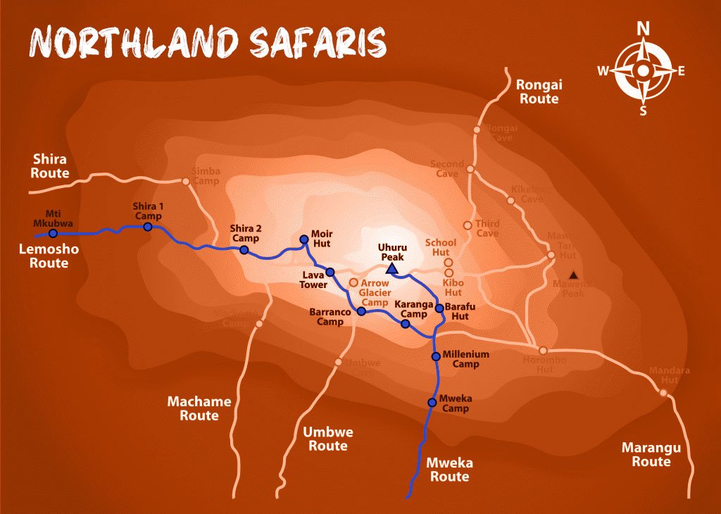


Lemosho Route
The Lemosho route is considered the most scenic trail on Kilimanjaro, granting panoramic vistas on various sides of the mountain.
As one of the newer Kilimanjaro routes, Lemosho is a superb choice for your climb. It is our preferred route due to its ideal balance of low crowds, beautiful scenery and a high summit success rate.
Ultimate Kilimanjaro® specializes in guiding on the Lemosho route. Most of our clients climb Kilimanjaro using this route and they consistently report that they love it. Thus, Lemosho is highly recommended.
The route approaches Mount Kilimanjaro from the west, beginning with a long drive from Moshi to Londorossi Gate. From there, the first two days are spent trekking through the rain forest to Shira Ridge. The Lemosho route crosses the entire Shira Plateau from west to east in a pleasant, relatively flat hike. Crowds are low until the route joins the Machame route near Lava Tower. Then the route traverses underneath Kilimanjaro’s Southern Ice Field on a path known as the Southern Circuit before summiting from Barafu. Descent is made via the Mweka route.
Northland Safaris offers Lemosho as an 8-day group climb or as a 7-to-9-day private climb.
The 8-day Lemosho route is the standard itinerary and is described in detail below.
The 7-day Lemosho variation shaves a day off the standard itinerary by combining days 5 and 6, going from Barranco Camp to Barafu Camp without staying at Karanga.
The 9-day Lemosho “daytime summit” route shortens the summit day by beginning the summit bid in the daytime and returning and staying at Barafu Camp (instead of going to Mweka Camp). This variation eliminates the midnight summit attempt, which is typically very cold and windy, but uses an additional day to complete the descent. You can read more about this route here.
Another 9-day variation, known as Lemosho Crater, includes an overnight stay at Crater Camp, which is located just under the summit. This route is available as a private climb by special request.
How Long is the Lemosho Route?
The distance of the Lemosho route is approximately 70 km or 42 miles. The total elevation gains ranges from approximately 16,000 to 17,000 feet.
How Many Days Does It Take to Climb Kilimanjaro on the Lemosho Route?
The Lemosho route has several variations and thus, the trail can be completed in as little as 6 days and as many as 9 days. The standard itinerary is the preferred variation which requires 8 days.
How Hard is it to Climb Kilimanjaro on the Lemosho Route?
The Lemosho route is considered a moderately difficult route due to its distance and elevation gain. The up and down nature of the trail is strenuous. However, when you factor in the favorable acclimatization schedule, it is very manageable.
What is the Success Rate of Climbing Kilimanjaro on the Lemosho Route?
The success rate depends on the number of days you spend on the mountain. For all operators combined, it is estimated that 6-day Lemosho climbs have a success rate of about 60%, 7-day Lemosho climbs have a success rate of around 80%-, and 8-day Lemosho climbs have a success rate of about 90%. Our success rate for 8- and 9-day Lemosho has historically ranged between 90-95%.
How Much Does It cost to Climb Kilimanjaro on the Lemosho Route?
The cost of the Lemosho route varies based on the number of days. Our current pricing for group climbs on the 8-day Lemosho route is $3,550 per person.
Included/Excluded
- Park fees (for non-residents)
- All activities (unless labeled as optional)
- All accommodation as stated in the itinerary
- A professional driver/guide
- All transportation (unless labeled as optional)
- All Taxes/VAT
- Roundtrip airport transfer
- All Meals (as specified in the day-by-day section)
- Drinking water on all days
- Park fees (for non-residents)
- Additional accommodation before and at the end of the tour
- Tips (tipping guideline US$20.00 pp per day)
- Personal items (souvenirs, travel insurance, visa fees, etc.)
- Government imposed increase of taxes and/or park fees
- Alcohol drinks
Tour Plan
- Elevation: 7,742 ft to 9,498 ft
- Hiking Time: 3-4 hours
- Distance: 6 km | 4 miles
- Habitat: Rain Forest
We depart Moshi for Londorossi Gate, which takes about 4 hours, where you will complete entry formalities. Then drive to the Lemosho trailhead. Upon arrival at trailhead, we begin hiking through undisturbed forest which winds to the first camp site.
- Elevation: 9,498 ft to 11,500 ft
- Hiking Time: 5-6 hours
- Distance: 8 km | 5 miles
- Habitat: Heath
We continued the trail leading out of the rain forest and into a savannah of tall grasses, heather and volcanic rock draped with lichen beards. As we ascend through the lush rolling hills and cross several streams, we reach the Shira Ridge before dropping gently down to Shira 1 Camp. Here we catch our first glimpse of Kibo across the plateau.
- Elevation: 11,500 ft to 13,800 ft
- Hiking Time: 5-7 hours
- Distance: 11 km | 7 miles
- Habitat: Heath
We explored the Shira Plateau for a full day. It is a gentle walk east on moorland meadows towards Shira 2 Camp. Then we divert from the main trail to Moir Hut, a little used site on the base of Lent Hills. A variety of walks are available on Lent Hills, making this an excellent opportunity to acclimatize. Shira Plateau is one of the highest plateaus on earth.
Moir Hut to Lava Tower
- Elevation: 13,800 ft to 15,190 ft
- Hiking Time: 4-5 hours
- Distance: 7 km | 4 miles
- Habitat: Alpine Desert
Lava Tower to Barranco Camp
- Elevation: 15,190 ft to 13,044 ft
- Hiking Time: 2-3 hours
- Distance: 3 km | 2 miles
- Habitat: Alpine Desert
We begin the day climbing up a ridge and then head southeast towards the Lava Tower – a 300 ft tall volcanic rock formation. We descend to Barranco Camp through the strange but beautiful Senecio Forest to an altitude of 13,000 ft. Although you begin and end the day at the same elevation, the time spent at higher altitude is very beneficial for acclimatization.
- Elevation: 13,044 ft to 13,106 ft
- Hiking Time: 4-5 hours
- Distance: 5 km | 3 miles
- Habitat: Alpine Desert
We begin the day by descending into a ravine to the base of the Great Barranco Wall. Then we climbed the non-technical but steep, nearly 900 ft cliff. From the top of the Barranco Wall we cross a series of hills and valleys until we descend sharply into Karanga Valley. One more steep climb up leads us to Karanga Camp. This is a shorter day meant for acclimatization.
- Elevation: 13,106 ft to 15,331 ft
- Hiking Time: 4-5 hours
- Distance: 4 km | 2 miles
- Habitat: Alpine Desert
We leave Karanga and hit the junction which connects with the Mweka Trail. We continue up to the rocky section to Barafu Hut. At this point, you have completed the Southern Circuit, which offers views of the summit from many different angles. Here we camp, rest and enjoy an early dinner to prepare for the summit day. The two peaks of Mawenzi and Kibo are viewable from this position.
Barafu Camp to Uhuru Peak
- Elevation: 15,331 ft to 19,341 ft
- Hiking Time: 6-8 hours
- Distance: 5 km | 3 miles
- Habitat: Arctic
Uhuru Peak to Mweka Camp
- Elevation: 19,341 ft to 10,065 ft
- Hiking Time: 4-6 hours
- Distance: 12 km | 7 miles
- Habitat: Rain Forest
Very early in the morning (around midnight), we begin our push to the summit. This is the most mentally and physically challenging portion of the trek. The wind and cold at this elevation and time of day can be extreme. We ascend in the darkness for several hours while taking frequent, but short, breaks. Near Stella Point (18,900 ft), you will be rewarded with the most magnificent sunrise you are ever likely to see coming over Mawenzi Peak. Finally, we arrive at Uhuru Peak– the highest point on Mount Kilimanjaro and the continent of Africa.
From the summit, we now make our descent continuing straight down to the Mweka Hut camp site, stopping at Barafu for lunch. The trail is very rocky and can be quite hard on the knees; trekking poles are helpful. Mweka Camp is situated in the upper forest and there is mist, or rain can be expected in the late afternoon. Later in the evening, we enjoy our last dinner on the mountain and have a well-earned sleep.
- Elevation: 10,065 ft to 5,380 ft
- Hiking Time: 3-4 hours
- Distance: 10 km | 6 miles
- Habitat: Rain Forest
On our last day, we continued the descent to Mweka Gate and collected the summit certificates. At lower elevations, it can be wet and muddy. A vehicle will meet us at Mweka Village to drive us back to the hotel in Moshi or Arusha.
Tour Map